Please note : This help page is not for the latest version of Enterprise Architect. The latest help can be found here.
ArcGIS Toolbox Pages
The ArcGIS Toolbox pages provide elements and connectors that enable you to model ArcGIS geodatabase concepts and relationships.
Access View | Diagram Toolbox: More Tools | ArcGIS
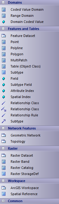
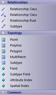
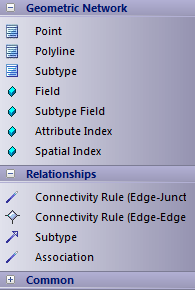
Diagram toolbox icons
Toolbox Icon |
Description |
||||
|---|---|---|---|---|---|
Elements |
|||||
ArcGIS Workspace |
The geodatabase workspace package, which holds all the ArcGIS modeling elements. Export the contents of this package to produce the Geodatabase XML Workspace Document, which can be imported to Esri ArcCatalog.
|
||||
Feature Dataset |
A stereotyped package that holds or organizes the Point, Polyline, Polygon or Multipatch elements with the same spatial reference. The Feature Dataset is only created under the ArcGIS Workspace package; it can not be created under another Feature Dataset package.
|
||||
Geometric Network |
An extended UML Package that represents the logical relationships between features in a network system - implemented in ArcGIS as a geometric network.
|
||||
Raster Dataset |
A stereotyped package that holds or organizes the raster data (as Raster Band elements; see below).
|
||||
Coded Value Domain |
An extended UML Class, representing a set of valid values that might apply to any type of attribute.
|
||||
Range Domain |
An extended UML Class, representing a valid range of numeric values that might apply to a numeric type of attribute.
|
||||
Point |
An extended UML Class, representing the ArcGIS Point.
|
||||
Polyline |
An extended UML Class, representing the ArcGIS Polyline.
|
||||
Polygon |
An extended UML Class, representing the ArcGIS Polygon.
|
||||
MultiPatch |
An extended UML Class, representing the ArcGIS MultiPatch.
|
||||
Raster Band |
An extended UML Class, representing one layer of a matrix of cell values. Every Raster Dataset contains one or more Raster Bands.
|
||||
Raster Catalog |
An extended UML Class, representing a collection of Raster Datasets in the geodatabase.
|
||||
Subtype |
An extended UML Class, holding a subset of the attributes of an element in the Feature Dataset.
|
||||
Table (Object Class) |
An extended UML Class, representing a collection of nonspatial data of the same type or Class.
|
||||
Topology |
An extended UML Package that represents the shared geometry of a set of feature classes from a feature dataset.
|
||||
Relationships |
|||||
Connectivity Rule (Edge-Junction) |
An extended UML n-ary Association that models the valid relationships between edge and junction elements in a geometric network.
|
||||
Connectivity Rule (Edge-Edge) |
An extended UML Association that models the valid relationships between edge elements in a geometric network.
|
||||
Subtype |
An extended UML Association, providing the relationship between a Feature Class element and a Subtype element.
|
||||
RelationshipClass |
An extended UML Association, providing the relationship between:
|
||||
RelationshipClass |
An extended UML Association Class, providing the attributed relationship between:
|
||||
Relationship Rule |
An extended UML Association that determines which subtypes can be related in the geodatabase.
|
||||
Supported Types |
|||||
Field |
An extended UML attribute that represents an ArcGIS field of the geodatabase, in a table or feature class.
|
||||
Subtype |
An extended UML Attribute that represents the subtype field of an ArcGIS table or feature class.
|
||||
DomainCodedValue |
An extended UML Attribute that specifies the value of an ArcGIS Coded Value Domain.
|
||||
Attribute Index |
An extended UML Attribute that represents the ArcGIS Attribute Index.
|
||||
Spatial Index |
An extended UML Attribute that represents the ArcGIS Spatial Index.
|
||||
Raster StorageDef |
An extended UML Class, representing the storage properties for a Raster value in the geodatabase; this information is required when a Raster Dataset element is created.
|
||||
Spatial Reference |
An extended UML Class that defines the spatial reference information of your schema, such as a coordinate system and XYTolerance. You can define one or more Spatial Reference elements, which you link to other ArcGIS elements via their Spatial Reference Tagged Value.
|
||||