Please note : This help page is not for the latest version of Enterprise Architect. The latest help can be found here.
ArcGIS
Topic under construction. The ArcGIS Profile is in Beta stage.
ArcGIS is a suite of Geographic Information Systems (GIS) software products developed by Esri.
Access: Diagram Toolbox: More Tools | ArcGIS
Topics:
Images |
Topic |
Detail |
See also |
|---|---|---|---|
|
ArcGIS in Enterprise Architect |
Enterprise Architect provides - through the integration of MDG Technologies with the installer - the facilities of ArcGIS ArcGIS modeling support is provided in the form of:
|
|
|
ArcGIS Toolbox Pages |
The ArcGIS Toolbox contains three pages:
|
|
|
Disable ArcGIS |
If you prefer not to use ArcGIS in Enterprise Architect, you can disable it (and subsequently re-enable it) using the MDG Technologies dialog (Settings | MDG Technologies) |
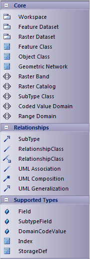
Diagram Toolbox Icons:
ArcGIS Icon |
Description |
|---|---|
Elements |
|
ArcGIS Workspace |
The geodatabase workspace package, which holds all the ArcGIS modeling elements Export the contents of this package to produce the Geodatabase XML Workspace Document, which can be imported to ESRI ArcCatalog |
Feature Dataset |
A stereotyped package that holds or organizes the Feature Classes with the same spatial reference The Feature Dataset is only created under the ArcGIS Workspace package; it can not be created under another Feature Dataset package |
Raster Dataset |
A stereotyped package that holds or organizes the raster data (as Raster Band elements; see below) |
Feature Class |
An extended UML Class, representing a collection of geographic features with the same geometry type, the same attributes and the same spatial reference Five types of Feature Class have been defined in Enterprise Architect:
|
Object Class |
An extended UML Class, representing a collection of nonspatial data of the same type or Class |
Geometric Network |
An extended UML Class, used to model the network system |
Raster Band |
An extended UML Class, representing one layer of a matrix of cell values Every Raster Dataset contains one or more Raster Bands |
Raster Catalog |
An extended UML Class, representing a collection of Raster Datasets in the geodatabase |
SubType Class |
An extended UML Class, holding a subset of the attributes of a Feature Class element |
Coded Value Domain |
An extended UML Class, representing a set of valid values that might apply to any type of attribute |
Range Domain |
An extended UML Class, representing a valid range of numeric values that might apply to a numeric type of attribute |
Relationships |
|
Subtype |
An extended UML Association, providing the relationship between a Feature Class element and a SubType Class element |
RelationshipClass |
An extended UML Association, providing the relationship between:
|
RelationshipClass |
An extended UML Association Class, providing the attributed relationship between:
|
UML Association |
A normal UML Association |
UML Composition |
A normal UML Composition |
UML Generalization |
A normal UML Generalization |