| Prev | Next |
ArcGIS Geodatabases
Exchange, Model and Visualize ArcGIS Geodatabases
Enterprise Architect allows you to import and export ArcGIS geodatabses allowing you to visualize Features and Domains within this powerful collaboration platform. In the recent past there has been a separation of the disciplines of system and software development and geospatial development. In this age of social architecture and digital disruption almost every project and endeavor requires some aspect of location information from simple delivery services to agricultural, mining, exploration, weather, real estate and disaster recovery systems.
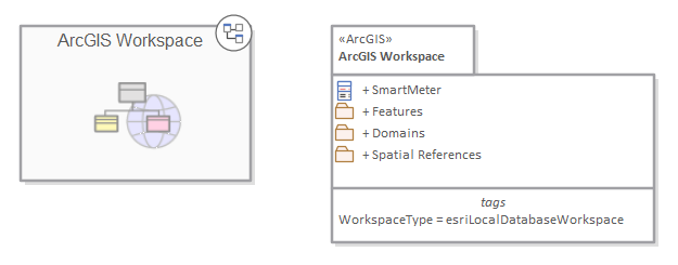
Package diagram showing a navigation cell and a Package containing Features Domains and a Geospatial Reference
The ArcGIS system, developed by Esri, supports the development and management of geodatabases. As it is for other databases, it is useful to model the design of a geodatabase using a standard notation such as UML. You can perform such modeling in Enterprise Architect, using the UML profile for ArcGIS, which is part of the built-in MDG Technology for ArcGIS. Once you have modeled an ArcGIS schema in Enterprise Architect, you can export the model to ArcGIS as an XML Workspace document. You can also visualize an existing ArcGIS geodatabase schema, by importing the ArcGIS XML Workspace document into Enterprise Architect.